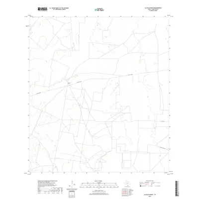
2019 Map of Las Islas Ranch
USGS Topo · Published 2019About this map
Las Islas Ranch anchors this portion of Starr County, situated along a network of remote ranching roads that crisscross the arid South Texas landscape. This 2019 survey, produced by the U.S. Geological Survey using imagery from the National Agriculture Imagery Program (NAIP), reveals a territory defined by expansive grazing lands and a sparse but deliberate infrastructure. The map follows the path of Ranch Rd 2686 as it cuts through the terrain, connecting isolated ranch sites. Smaller routes like Alaniz Rd and San Blas Ranch Rd branch off from the main thoroughfares, providing access to private holdings. The terrain is marked by subtle shifts in elevation, meticulously captured by the National Elevation Dataset, showing the dry drainage patterns and land contours that dictate the layout of these vast cattle operations in the borderlands region.
Find a feature on this map
4 named features on this map. Tap any name to fly to it.
Don’t see what you’re looking for? This feature index may not catch every label — zoom into the map to look around manually.
Map Details
Editions of this 2019 Las Islas Ranch Map
This is the sole edition of this map. No revisions or reprints were ever made.
Other maps of this area

1938 · El Sauz
USGS Topo · 1:62,500

1938 · Agua Nueva
USGS Topo · 1:62,500

1938 · Sal Colorada
USGS Topo · 1:62,500

1938 · Cuevitas
USGS Topo · 1:62,500

1949 · Mc Allen
USGS Topo · 1:250,000

1954 · McAllen
USGS Topo · 1:250,000

1957 · Mc Allen
USGS Topo · 1:250,000

1962 · McAllen
USGS Topo · 1:250,000

1972 · Cuevitas
USGS Topo · 1:24,000
1972 · Viboras
USGS Topo · 1:24,000