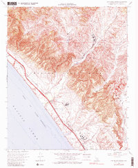
1968 Map of Las Pulgas Canyon
USGS Topo · Published 1982About this map
Camp Pendleton Marine Corps Base dominates this coastal landscape, illustrating the military's transformation of the Santa Margarita Mountains and the shoreline of the Gulf of Santa Catalina during the mid-20th century. The map highlights a complex infrastructure of training grounds, including multiple areas designated as Rifle Range and a Landing Strip, alongside historical remnants like the Asistencia de Las Flores (Ruins). This mission-era estancia remains a significant cultural anchor near Las Flores Creek, marking the site's transition from Spanish pastoral lands to a high-activity Marine training facility.
Find a feature on this map
33 named features on this map. Tap any name to fly to it.
Don’t see what you’re looking for? This feature index may not catch every label — zoom into the map to look around manually.
Map Details
Editions of this 1968 Las Pulgas Canyon Map
3 editions found
Other maps of this area

1893 · Oceanside
USGS Topo · 1:62,500

1898 · Oceanside
USGS Topo · 1:62,500

1901 · Oceanside
USGS Topo · 1:62,500

1901 · San Luis Rey
USGS Topo · 1:125,000

1902 · Capistrano
USGS Topo · 1:125,000

1904 · Southern California Sheet No. 2
USGS Topo · 1:250,000

1906 · Capistrano
USGS Topo · 1:125,000

1941 · Margarita Peak
USGS Topo · 1:62,500

1942 · Margarita Peak
USGS Topo · 1:62,500

1942 · San Juan Capistrano
USGS Topo · 1:62,500
Featured Places
- Marine Corps Base Camp Pendleton, CA
- Las Flores, Marine Corps Base Camp Pendleton
- San Diego County, CA
- United States
- California