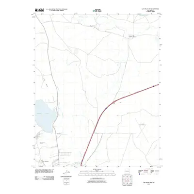
2010 Map of Las Vegas NW
USGS Topo · Published 2010About this map
Storrie Lake and its surrounding high-desert drainage systems anchor this 2010 survey of the northwestern outskirts of Las Vegas. The landscape is defined by the winding course of the Sapello River to the north and the deep channel of Arroyo Pecos cutting through the center. Small settlements and named locales like Emplazado, San Antonio, and Gerk are interspersed between local landmarks and essential services. Genealogists and local historians can locate established burial grounds including North Pilgrims Rest Cemetery and Saint Anthonys Cemetery, while the presence of the Los Alamos Post Office and Las Vegas Municipal Airport highlights the infrastructure serving this portion of San Miguel County. The map also detail irrigation and water management features such as the Lake Isabel Inlet Ditch, which connects higher elevations to Lake Isabel at the northern edge of the quadrangle.
Find a feature on this map
27 named features on this map. Tap any name to fly to it.
Don’t see what you’re looking for? This feature index may not catch every label — zoom into the map to look around manually.
Map Details
Editions of this 2010 Las Vegas NW Map
This is the sole edition of this map. No revisions or reprints were ever made.
Other maps of this area

1889 · Las Vegas
USGS Topo · 1:125,000

1891 · Las Vegas
USGS Topo · 1:125,000

1893 · Las Vegas
USGS Topo · 1:125,000

1954 · Santa Fe
USGS Topo · 1:250,000

1958 · Santa Fe
USGS Topo · 1:250,000

1961 · Montezuma
USGS Topo · 1:24,000
1961 · Ojitos Frios
USGS Topo · 1:24,000

1963 · Lake Isabel
USGS Topo · 1:24,000
1963 · Las Vegas SE
USGS Topo · 1:24,000
1963 · Las Vegas
USGS Topo · 1:24,000