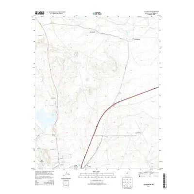
2013 Map of Las Vegas NW
USGS Topo · Published 2013About this map
Las Vegas anchors the southern portion of this landscape, where the high plains meet the eastern foothills of the Sangre de Cristo Mountains. The geography is defined by a complex network of water management, including the Storrie Lake reservoir and the N Storrie Inlet Canal, which divert flows to support this arid region's ranching and municipal needs. To the north, small traditional settlements like Emplazado and Los Alamos sit along the Sapello River, connected by Co Road A6. Local history is preserved at sites like N Pilgrims Rest Cem and Saint Anthonys Cem, while the modern infrastructure of the Las Vegas Municipal Airport and the path of NM-250 reflect the area's continued role as a regional transit hub. The map captures the transition from structured town streets like Dora Celeste Dr and Harris Rd into the expansive grazing lands and arroyos of San Miguel County.
Find a feature on this map
38 named features on this map. Tap any name to fly to it.
Don’t see what you’re looking for? This feature index may not catch every label — zoom into the map to look around manually.
Map Details
Editions of this 2013 Las Vegas NW Map
This is the sole edition of this map. No revisions or reprints were ever made.
Other maps of this area

1889 · Las Vegas
USGS Topo · 1:125,000

1891 · Las Vegas
USGS Topo · 1:125,000

1893 · Las Vegas
USGS Topo · 1:125,000

1954 · Santa Fe
USGS Topo · 1:250,000

1958 · Santa Fe
USGS Topo · 1:250,000

1961 · Montezuma
USGS Topo · 1:24,000
1961 · Ojitos Frios
USGS Topo · 1:24,000

1963 · Lake Isabel
USGS Topo · 1:24,000
1963 · Las Vegas SE
USGS Topo · 1:24,000
1963 · Las Vegas
USGS Topo · 1:24,000