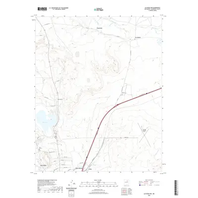
2020 Map of Las Vegas NW
USGS Topo · Published 2020About this map
Storrie Lake and its sophisticated irrigation infrastructure, including the N Storrie Inlet Canal and the Lake Isabel Inlet Ditch, dominate this landscape north of the modern city limits. The terrain is characterized by a series of drainages such as Arroyo Pecos and Gallinas Cr that flow through a region marked by small historical settlements like Emplazado, Los Alamos, and San Antonio. This map documents the complex water management systems essential to New Mexico's high-desert environment, showing how natural watercourses like the Sapello River are diverted for local use.
Find a feature on this map
42 named features on this map. Tap any name to fly to it.
Don’t see what you’re looking for? This feature index may not catch every label — zoom into the map to look around manually.
Map Details
Editions of this 2020 Las Vegas NW Map
This is the sole edition of this map. No revisions or reprints were ever made.
Other maps of this area

1889 · Las Vegas
USGS Topo · 1:125,000

1891 · Las Vegas
USGS Topo · 1:125,000

1893 · Las Vegas
USGS Topo · 1:125,000

1954 · Santa Fe
USGS Topo · 1:250,000

1958 · Santa Fe
USGS Topo · 1:250,000

1961 · Montezuma
USGS Topo · 1:24,000
1961 · Ojitos Frios
USGS Topo · 1:24,000

1963 · Lake Isabel
USGS Topo · 1:24,000
1963 · Las Vegas SE
USGS Topo · 1:24,000
1963 · Las Vegas
USGS Topo · 1:24,000