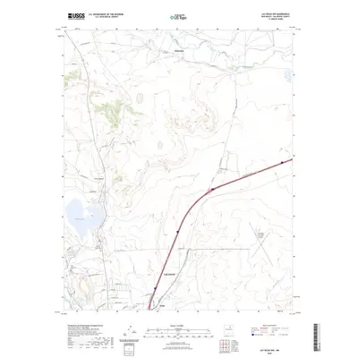
2023 Map of Las Vegas NW
USGS Topo · Published 2023About this map
Las Vegas occupies the southwestern corner of this modern survey, where the urban edge meets the expansive landscapes of San Miguel County. The terrain is defined by the course of the Sapello River to the north and the Arroyo Pecos and Arroyo de la Liendre winding through the central and southern sections. This contemporary record shows the northern growth of the city toward Arriba and the rural surroundings including Emplazado and Cañon Bonito. The infrastructure reflects a blend of local ranching access and major regional transit, with the Storrie Lake Canal cutting across the western valley to feed Storrie Lake. For researchers, the map provides a clear view of the modern boundaries between established settlements and the natural drainage patterns that have historically shaped land use in this part of New Mexico.
Find a feature on this map
4 named features on this map. Tap any name to fly to it.
Don’t see what you’re looking for? This feature index may not catch every label — zoom into the map to look around manually.
Map Details
Editions of this 2023 Las Vegas NW Map
This is the sole edition of this map. No revisions or reprints were ever made.
Other maps of this area

1889 · Las Vegas
USGS Topo · 1:125,000

1891 · Las Vegas
USGS Topo · 1:125,000

1893 · Las Vegas
USGS Topo · 1:125,000

1954 · Santa Fe
USGS Topo · 1:250,000

1958 · Santa Fe
USGS Topo · 1:250,000

1961 · Montezuma
USGS Topo · 1:24,000
1961 · Ojitos Frios
USGS Topo · 1:24,000

1963 · Lake Isabel
USGS Topo · 1:24,000
1963 · Las Vegas SE
USGS Topo · 1:24,000
1963 · Las Vegas
USGS Topo · 1:24,000