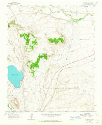
1963 Map of Las Vegas NW
USGS Topo · Published 1965About this map
The Las Vegas Grant Boundary defines much of this northern New Mexico landscape in the early 1960s, where traditional land use and modern infrastructure meet. High-altitude water management is central to the area, evidenced by Storrie Lake and its associated Storrie Lake Intake Canal and Storrie Project Irrigation Canal, which feed the surrounding agricultural efforts. Near the northern edge of Las Vegas City, the map shows a transition from urban development to the high plains, featuring landmarks such as the Las Vegas Municipal Airport and the Drive-in Theater. Small settlements like Los Alamos and Emplazado sit near the Sapello River, while the southern portion reveals the cultural heritage of the region through St Anthonys Cemetery and North Pilgrims Rest Cemetery. The historic Old Santa Fe Trail runs alongside the Atchison Topeka and Santa Fe railroad, tracing the path of westward expansion.
Find a feature on this map
32 named features on this map. Tap any name to fly to it.
Don’t see what you’re looking for? This feature index may not catch every label — zoom into the map to look around manually.
Map Details
Editions of this 1963 Las Vegas NW Map
This is the sole edition of this map. No revisions or reprints were ever made.
Other maps of this area

1889 · Las Vegas
USGS Topo · 1:125,000

1891 · Las Vegas
USGS Topo · 1:125,000

1893 · Las Vegas
USGS Topo · 1:125,000

1954 · Santa Fe
USGS Topo · 1:250,000

1958 · Santa Fe
USGS Topo · 1:250,000

1961 · Montezuma
USGS Topo · 1:24,000
1961 · Ojitos Frios
USGS Topo · 1:24,000

1963 · Lake Isabel
USGS Topo · 1:24,000
1963 · Las Vegas SE
USGS Topo · 1:24,000
1963 · Las Vegas
USGS Topo · 1:24,000