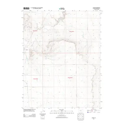
2013 Map of Lascar
USGS Topo · Published 2013About this map
The Huerfano River meanders through this Huerfano County landscape, its course flanked by a network of ephemeral drainages and arroyos. The small settlement of Lascar serves as a primary point of reference, situated near where Apache Cr joins the larger river system. The geography is defined by its water management and drainage patterns, featuring the Bradford Canal in the southern reaches and numerous named watercourses like Mustang Arroyo and Pine Arroyo that cut through the terrain. The area's reliance on these water sources is further evidenced by landmarks such as Rock Spring and its associated Rock Spring Arroyo. Local roads including Co RD-110 and Co RD-122 provide a grid for navigating the township and range boundaries that organize this part of Colorado.
Find a feature on this map
19 named features on this map. Tap any name to fly to it.
Don’t see what you’re looking for? This feature index may not catch every label — zoom into the map to look around manually.
Map Details
Editions of this 2013 Lascar Map
This is the sole edition of this map. No revisions or reprints were ever made.
Other maps of this area

1891 · Walsenburg
USGS Topo · 1:125,000

1894 · Walsenburg
USGS Topo · 1:125,000

1897 · Walsenburg
USGS Topo · 1:125,000

1900 · Walsenburg
USGS Topo · 1:125,000

1954 · Trinidad
USGS Topo · 1:250,000

1955 · Trinidad
USGS Topo · 1:250,000

1958 · Trinidad
USGS Topo · 1:250,000

1959 · Trinidad
USGS Topo · 1:250,000
1963 · Walsenburg North
USGS Topo · 1:24,000
1963 · Maria Reservoir
USGS Topo · 1:24,000