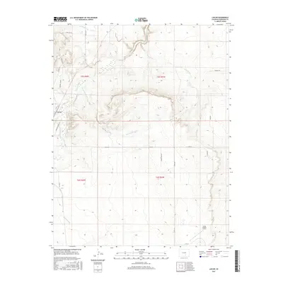
2016 Map of Lascar
USGS Topo · Published 2016About this map
Lascar marks a quiet crossing in the high plains of southern Colorado where the Huerfano River carves its way through the landscape. This 2016 survey illustrates the remote, ranch-dominated character of Huerfano County, defined by its complex network of seasonal drainages including Mustang Arroyo, Pine Arroyo, and Rock Spring Arroyo. The presence of the Bradford Canal indicates the importance of water management in this arid region, while the Flying D Ranch Airport serves as a modern touchstone for large-scale landholdings. Local road names like School House Dr and Lonesome Whistle Rd hint at the area's rural heritage and the former path of the railroad that once connected these isolated settlements to the wider world.
Find a feature on this map
27 named features on this map. Tap any name to fly to it.
Don’t see what you’re looking for? This feature index may not catch every label — zoom into the map to look around manually.
Map Details
Editions of this 2016 Lascar Map
This is the sole edition of this map. No revisions or reprints were ever made.
Other maps of this area

1891 · Walsenburg
USGS Topo · 1:125,000

1894 · Walsenburg
USGS Topo · 1:125,000

1897 · Walsenburg
USGS Topo · 1:125,000

1900 · Walsenburg
USGS Topo · 1:125,000

1954 · Trinidad
USGS Topo · 1:250,000

1955 · Trinidad
USGS Topo · 1:250,000

1958 · Trinidad
USGS Topo · 1:250,000

1959 · Trinidad
USGS Topo · 1:250,000
1963 · Walsenburg North
USGS Topo · 1:24,000
1963 · Maria Reservoir
USGS Topo · 1:24,000