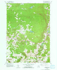
1945 Map of Lassellsville
USGS Topo · Published 1970About this map
Lassellsville and the surrounding township of Ephratah sit at the southern doorstep of the Adirondack Park in this 1940s-era survey. The map reveals a landscape defined by its transitional character between the mountainous north and the rolling hills of the Fulton and Montgomery County border. Local infrastructure of the mid-20th century is well-documented, featuring rural landmarks like Miles School, Shaver School, and the St Johnsville Reservoir. Smaller settlements such as Glasgow Mills and Newkirk are situated along the upper reaches of the Caroga Creek, while the southwestern corner transitions toward the settlements of St. Johnsville and Palatine. The map is particularly useful for genealogical research, identifying specific family-named locations such as Fical Corners, Scotchbush, and Sponable, along with local burial grounds like Christman Cem and the Rural Cem.
Find a feature on this map
45 named features on this map. Tap any name to fly to it.
Don’t see what you’re looking for? This feature index may not catch every label — zoom into the map to look around manually.
Map Details
Editions of this 1945 Lassellsville Map
3 editions found
Other maps of this area

1896 · Fonda
USGS Topo · 1:62,500

1898 · Fonda
USGS Topo · 1:62,500

1898 · Canajoharie
USGS Topo · 1:62,500

1900 · Canajoharie
USGS Topo · 1:62,500

1901 · Lassellsville
USGS Topo · 1:62,500

1902 · Canajoharie
USGS Topo · 1:62,500

1902 · Fonda
USGS Topo · 1:62,500

1903 · Gloversville
USGS Topo · 1:62,500

1903 · Lassellsville
USGS Topo · 1:62,500

1943 · Gloversville
USGS Topo · 1:62,500