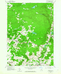
1945 Map of Lassellsville
USGS Topo · Published 1964About this map
Adirondack Park forms the northern backdrop for this mid-1940s survey of the borderlands between Fulton and Montgomery Counties. The landscape is defined by the complex drainage of Caroga Creek and its many tributaries, including Zimmerman Creek and Glasgow Creek, which powered local industry at sites like Glasgow Mills. Settlement patterns follow the winding creek valleys and rural road intersections, with small hamlets such as Lassellsville, Rockwood, and Ephratah serving as local hubs.
Find a feature on this map
41 named features on this map. Tap any name to fly to it.
Don’t see what you’re looking for? This feature index may not catch every label — zoom into the map to look around manually.
Map Details
Editions of this 1945 Lassellsville Map
3 editions found
Other maps of this area

1896 · Fonda
USGS Topo · 1:62,500

1898 · Fonda
USGS Topo · 1:62,500

1898 · Canajoharie
USGS Topo · 1:62,500

1900 · Canajoharie
USGS Topo · 1:62,500

1901 · Lassellsville
USGS Topo · 1:62,500

1902 · Canajoharie
USGS Topo · 1:62,500

1902 · Fonda
USGS Topo · 1:62,500

1903 · Gloversville
USGS Topo · 1:62,500

1903 · Lassellsville
USGS Topo · 1:62,500

1943 · Gloversville
USGS Topo · 1:62,500