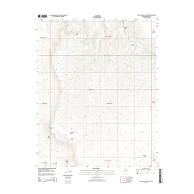
2014 Map of Last Chance Canyon
USGS Topo · Published 2014About this map
Last Chance Canyon and the Upper Grand Wash Cliffs define this high-desert landscape in Mohave County. The topography is marked by a network of drainage systems and isolated water sources, including Yellowstone Spring and Lower Hidden Spring. These natural catchments and springs were critical for early ranching and transit through the arid corridor. Named landmarks such as Hudson Point, Last Chance Knoll, and the Hidden Hills provide clear navigational markers across the varied elevations. The map also identifies specific geographic features like Squaw Pockets and Red Rock Knoll, which reflect the localized nomenclature of this corner of Arizona. The presence of North Tank and Lower North Tank suggests a reliance on managed water infrastructure alongside the natural springs like Gordon Spring and Coin Spring.
Find a feature on this map
33 named features on this map. Tap any name to fly to it.
Don’t see what you’re looking for? This feature index may not catch every label — zoom into the map to look around manually.
Map Details
Editions of this 2014 Last Chance Canyon Map
This is the sole edition of this map. No revisions or reprints were ever made.
Other maps of this area

1886 · Mt. Trumbull
USGS Topo · 1:250,000

1892 · Mt. Trumbull
USGS Topo · 1:250,000

1953 · Grand Canyon
USGS Topo · 1:250,000
1954 · Littlefield 3 SE
USGS Topo · 1:24,000

1954 · Cane Springs
USGS Topo · 1:62,500

1957 · Grand Canyon
USGS Topo · 1:250,000

1958 · Grand Canyon
USGS Topo · 1:250,000

1960 · Grand Canyon
USGS Topo · 1:250,000
1971 · Poverty Spring
USGS Topo · 1:24,000
1971 · Wildcat Ranch
USGS Topo · 1:24,000