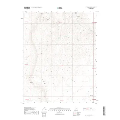
2021 Map of Last Chance Canyon
USGS Topo · Published 2021About this map
The Upper Grand Wash Cliffs dominate this portion of Mohave County, where the Arizona landscape is defined by deep drainage systems and high-desert water sources. The Last Chance Canyon serves as the central geographic feature, surrounded by markers like Last Chance Points and the prominent Last Chance Knoll. Water is a critical element in this environment, represented by a network of scattered seeps and tanks including Yellowstone Spring, Gordon Spring, and Rattlesnake Spring. This modern survey illustrates the complex topography from Hidden Rim to the Squaw Canyon area. The presence of features such as Squaw Pockets and Lower Hidden Spring points to a landscape where specific, named locations often revolve around the few reliable points of moisture and distinct landforms like Red Rock Knoll.
Find a feature on this map
35 named features on this map. Tap any name to fly to it.
Don’t see what you’re looking for? This feature index may not catch every label — zoom into the map to look around manually.
Map Details
Editions of this 2021 Last Chance Canyon Map
This is the sole edition of this map. No revisions or reprints were ever made.
Other maps of this area

1886 · Mt. Trumbull
USGS Topo · 1:250,000

1892 · Mt. Trumbull
USGS Topo · 1:250,000

1953 · Grand Canyon
USGS Topo · 1:250,000
1954 · Littlefield 3 SE
USGS Topo · 1:24,000

1954 · Cane Springs
USGS Topo · 1:62,500

1957 · Grand Canyon
USGS Topo · 1:250,000

1958 · Grand Canyon
USGS Topo · 1:250,000

1960 · Grand Canyon
USGS Topo · 1:250,000
1971 · Poverty Spring
USGS Topo · 1:24,000
1971 · Wildcat Ranch
USGS Topo · 1:24,000