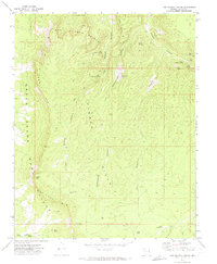
1971 Map of Last Chance Canyon
USGS Topo · Published 1974About this map
The Upper Grand Wash Cliffs dominate the western edge of this 1970s landscape, marking a massive geological transition in Mohave County. This era of land use is defined by isolated water improvements essential for livestock, such as the Hidden Pump Station, North Tank, and a Water Tank near the eastern boundary. The intricate drainage network of Last Chance Canyon, Rattlesnake Canyon, and Dry Canyon dissects the Hidden Hills, revealing a complex terrain where survival depended on reliable water sources like Yellowstone Spring and Lower Last Chance Spring. Named landmarks like Hudson Point and Last Chance Knoll provided essential orientation for those navigating the sparse Jeep Trail system. The map captures a moment in the American West when traditional ranching infrastructure, evidenced by a Corral and numerous springs, persisted in a formidable environment.
Find a feature on this map
32 named features on this map. Tap any name to fly to it.
Don’t see what you’re looking for? This feature index may not catch every label — zoom into the map to look around manually.
Map Details
Editions of this 1971 Last Chance Canyon Map
This is the sole edition of this map. No revisions or reprints were ever made.
Other maps of this area

1886 · Mt. Trumbull
USGS Topo · 1:250,000

1892 · Mt. Trumbull
USGS Topo · 1:250,000

1953 · Grand Canyon
USGS Topo · 1:250,000
1954 · Littlefield 3 SE
USGS Topo · 1:24,000

1954 · Cane Springs
USGS Topo · 1:62,500

1957 · Grand Canyon
USGS Topo · 1:250,000

1958 · Grand Canyon
USGS Topo · 1:250,000

1960 · Grand Canyon
USGS Topo · 1:250,000
1971 · Poverty Spring
USGS Topo · 1:24,000
1971 · Wildcat Ranch
USGS Topo · 1:24,000