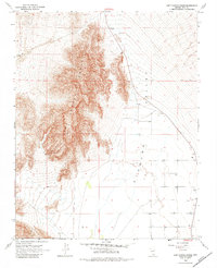
1968 Map of Last Chance Range
USGS Topo · Published 1984About this map
The Last Chance Range dominates this corner of Nye County, standing as a prominent geological barrier between the desert flats. To the east, the Pahrump Valley slopes gently away from the mountain base, marked by a scattering of isolated water sources such as Wells. This landscape reflects a period of quiet transition in the late 1960s, where the only signs of human activity in the high ground are a solitary Prospect and a rugged Jeep Trail crossing the eastern basin. The density of topographic contour lines illustrates the sharp verticality of the range, while the valley floor below shows a grid of section lines and localized wells that suggest the early stages of groundwater management and land surveying in this arid stretch of the Mojave.
Find a feature on this map
7 named features on this map. Tap any name to fly to it.
Don’t see what you’re looking for? This feature index may not catch every label — zoom into the map to look around manually.
Map Details
Editions of this 1968 Last Chance Range Map
2 editions found
Other maps of this area

1907 · Las Vegas
USGS Topo · 1:250,000

1908 · Furnace Creek
USGS Topo · 1:250,000

1908 · Las Vegas
USGS Topo · 1:250,000

1910 · Furnace Creek
USGS Topo · 1:250,000

1948 · Death Valley
USGS Topo · 1:250,000

1954 · Las Vegas
USGS Topo · 1:250,000

1954 · Death Valley
USGS Topo · 1:250,000

1956 · Death Valley
USGS Topo · 1:250,000

1957 · Las Vegas
USGS Topo · 1:250,000

1957 · Death Valley
USGS Topo · 1:250,000