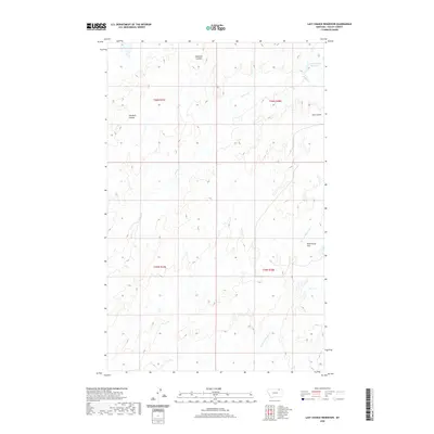
2020 Map of Last Chance Reservoir
USGS Topo · Published 2020About this map
Last Chance Reservoir serves as a primary water feature in this portion of Valley County, located at the northern edge of the map. The landscape is defined by the drainage patterns of Willow Cr and its tributary, W Fork Willow Cr, which carve through the high plains. This 2020 survey reveals a topography marked by numerous coulees, such as Chambers Coulee, Starbuck Coulee, and Cow Coulee, illustrating the erosional character of the northern Montana rangeland.
Find a feature on this map
11 named features on this map. Tap any name to fly to it.
Don’t see what you’re looking for? This feature index may not catch every label — zoom into the map to look around manually.
Map Details
Editions of this 2020 Last Chance Reservoir Map
This is the sole edition of this map. No revisions or reprints were ever made.
Other maps of this area

1919 · Boundary
USGS Topo · 1:125,000

1954 · Glasgow
USGS Topo · 1:250,000

1957 · Glasgow
USGS Topo · 1:250,000

1958 · Glasgow
USGS Topo · 1:250,000

1984 · Lighthouse Hill
USGS Topo · 1:24,000

1984 · Opheim
USGS Topo · 1:100,000

1984 · Gay Dam
USGS Topo · 1:24,000

1984 · Dodge Reservoir
USGS Topo · 1:24,000

1984 · Last Chance Reservoir
USGS Topo · 1:24,000
1984 · Burnett Creek
USGS Topo · 1:24,000