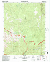
1995 Map of Latir Peak
USGS Topo · Published 1997About this map
Sangre de Cristo Mountains dominate this high-altitude landscape in northern New Mexico, where the peaks of the Culebra Range meet the vast timberlands of the Carson National Forest Wilderness. In the mid-1990s, this area served as a focal point for both winter recreation at the Rio Costilla Ski Area and remote backcountry exploration. Notable summits like Latir Peak, Virsvylvia Peak, and Baldy Mountain surround a series of glacial basins, including the cluster of Latir Lakes and Heart Lake. The map reveals the intricate land management boundaries of the era, specifically the Grant Boundary and National Forest Boundary, which intersect near the Latir Rock Cairn. A lone prospect and the isolated Baldy Cabin are the only signs of human industry and habitation in this high-alpine wilderness, illustrating the transition from early mining interests to modern conservation and recreational use.
Find a feature on this map
32 named features on this map. Tap any name to fly to it.
Don’t see what you’re looking for? This feature index may not catch every label — zoom into the map to look around manually.
Map Details
Editions of this 1995 Latir Peak Map
This is the sole edition of this map. No revisions or reprints were ever made.
Other maps of this area

1954 · Raton
USGS Topo · 1:250,000

1958 · Raton
USGS Topo · 1:250,000

1963 · Costilla
USGS Topo · 1:24,000

1963 · Amalia
USGS Topo · 1:24,000

1963 · Red River Pass
USGS Topo · 1:24,000

1963 · Cerro
USGS Topo · 1:24,000

1963 · Questa
USGS Topo · 1:24,000

1963 · Latir Peak
USGS Topo · 1:24,000

1963 · Comanche Point
USGS Topo · 1:24,000

1963 · Red River
USGS Topo · 1:24,000