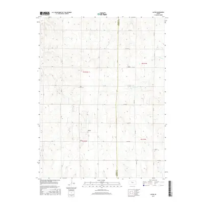
2015 Map of Laton
USGS Topo · Published 2015About this map
The settlement of Laton anchors this rural landscape along the border of Rooks and Osborne Counties. The terrain is defined by the winding paths of Medicine Cr, Eagle Cr, and Lucky Cr, which cut through the high plains. A clear grid of section roads and rural routes, such as Co Rd 31 and S 280th Ave, connects the isolated farmsteads and agricultural plots of this Kansas region. For those researching local family history or the burial sites of early pioneers, the map identifies several geographically distinct cemeteries, including Pleasant Plain Cem in the northeast and Chalk Mound Cem further west. These markers, along with Aurora Cem and the Lutheran Cem, provide essential anchor points for understanding the early community structure and settlement patterns of T8S and T9S in Rooks County.
Find a feature on this map
36 named features on this map. Tap any name to fly to it.
Don’t see what you’re looking for? This feature index may not catch every label — zoom into the map to look around manually.
Map Details
Editions of this 2015 Laton Map
This is the sole edition of this map. No revisions or reprints were ever made.
Other maps of this area

1896 · Osborne
USGS Topo · 1:125,000

1896 · Plainville
USGS Topo · 1:125,000

1953 · Woodston NW
USGS Topo · 1:24,000

1953 · Woodston
USGS Topo · 1:24,000

1953 · Alton
USGS Topo · 1:24,000

1955 · Beloit
USGS Topo · 1:250,000

1959 · Beloit
USGS Topo · 1:250,000
1978 · Natoma
USGS Topo · 1:24,000
1978 · Paradise NW
USGS Topo · 1:24,000
1978 · Alton SW
USGS Topo · 1:24,000