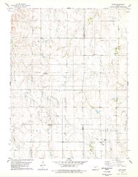
1978 Map of Laton
USGS Topo · Published 1979About this map
The rolling plains of Rooks and Osborne Counties appear here during the late 1970s, defined by a sparse network of rural settlements and agricultural land. The small community of Laton sits centrally, supported by nearby landmarks such as the Aurora Cemetery and a local Quarry. Further north, the landscape is marked by the prominence of Mount Ayr, while Medicine Creek winds through the eastern sections.
Find a feature on this map
20 named features on this map. Tap any name to fly to it.
Don’t see what you’re looking for? This feature index may not catch every label — zoom into the map to look around manually.
Map Details
Editions of this 1978 Laton Map
This is the sole edition of this map. No revisions or reprints were ever made.
Other maps of this area

1896 · Osborne
USGS Topo · 1:125,000

1896 · Plainville
USGS Topo · 1:125,000

1953 · Woodston NW
USGS Topo · 1:24,000

1953 · Woodston
USGS Topo · 1:24,000

1953 · Alton
USGS Topo · 1:24,000

1955 · Beloit
USGS Topo · 1:250,000

1959 · Beloit
USGS Topo · 1:250,000
1978 · Natoma
USGS Topo · 1:24,000
1978 · Paradise NW
USGS Topo · 1:24,000
1978 · Alton SW
USGS Topo · 1:24,000