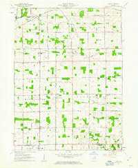
1961 Map of Laud
USGS Topo · Published 1963About this map
The Laud area of Indiana is defined by its deep agrarian roots and a geometric grid of rural routes, including the historically significant Indian Treaty Road and Old Indian Treaty Road. Settlement in the early 1960s was clustered around small rail-side stops and crossroads, with the New York Chicago and St Louis railroad cutting west-to-east through the communities of Peabody, Briggs, and Raber. In the northwest corner, the Eel River flows past Gravel Pits, while numerous drainage features like Gangwer Ditch support the surrounding farmland.
Find a feature on this map
41 named features on this map. Tap any name to fly to it.
Don’t see what you’re looking for? This feature index may not catch every label — zoom into the map to look around manually.
Map Details
Editions of this 1961 Laud Map
Other maps of this area

1953 · Fort Wayne
USGS Topo · 1:250,000

1953 · Muncie
USGS Topo · 1:250,000

1955 · Bippus
USGS Topo · 1:24,000

1955 · Columbia City
USGS Topo · 1:24,000

1956 · Muncie
USGS Topo · 1:250,000

1956 · Fort Wayne
USGS Topo · 1:250,000

1956 · Huntington
USGS Topo · 1:24,000

1956 · Lorane
USGS Topo · 1:24,000

1957 · Churubusco
USGS Topo · 1:24,000

1961 · Arcola
USGS Topo · 1:24,000