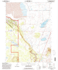
1993 Map of Lauer Reservoir
USGS Topo · Published 1996About this map
The high desert landscape of Modoc County is dominated by the storage and movement of water in this 1993 study. Lauer Reservoir and the Davis Creek Orchards Reservoir serve as central landmarks, reflecting the importance of irrigation and livestock management in the arid West. The terrain transitions from the volcanic slopes of Round Mountain and the protection of the Modoc National Forest to the drainage systems of the North Fork Pit River and Russell Slough.
Find a feature on this map
17 named features on this map. Tap any name to fly to it.
Don’t see what you’re looking for? This feature index may not catch every label — zoom into the map to look around manually.
Map Details
Editions of this 1993 Lauer Reservoir Map
This is the sole edition of this map. No revisions or reprints were ever made.
Other maps of this area

1886 · Alturas
USGS Topo · 1:250,000

1892 · Alturas
USGS Topo · 1:250,000

1954 · Alturas
USGS Topo · 1:250,000

1958 · Alturas
USGS Topo · 1:250,000

1962 · Alturas
USGS Topo · 1:250,000

1962 · Davis Creek
USGS Topo · 1:62,500

1962 · Big Sage Reservoir
USGS Topo · 1:62,500

1962 · Willow Ranch
USGS Topo · 1:62,500

1962 · South Mountain
USGS Topo · 1:62,500

1965 · Alturas
USGS Topo · 1:250,000