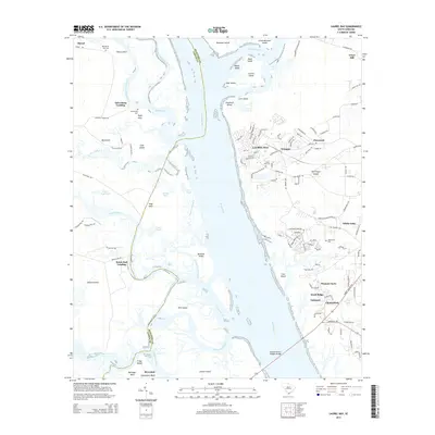
2014 Map of Laurel Bay
USGS Topo · Published 2014About this map
The Broad River serves as the central artery for this South Carolina coastal region, separating the interior marshes of Jasper Co from the developed communities of Port Royal Island. On the eastern bank, the concentrated residential layout of Laurel Bay is flanked by several small neighborhoods such as Irongate, Pinewood, and White Oaks. This area exhibits a transition from established settlements to the expansive wetlands and tidal creeks that define the Lowcountry. Along the western reaches, names like Salvesbarg Landing and Bolon Hall Landing indicate long-standing access points to the complex network of waterways, including Boyd Creek and Euhaw Creek.
Find a feature on this map
130 named features on this map. Tap any name to fly to it.
Don’t see what you’re looking for? This feature index may not catch every label — zoom into the map to look around manually.
Map Details
Editions of this 2014 Laurel Bay Map
This is the sole edition of this map. No revisions or reprints were ever made.
Other maps of this area

1918 · Green Pond
USGS Topo · 1:62,500

1918 · Yemassee
USGS Topo · 1:62,500

1920 · Okatie
USGS Topo · 1:62,500

1942 · Okatie
USGS Topo · 1:62,500

1943 · Yemassee
USGS Topo · 1:62,500

1943 · Green Pond
USGS Topo · 1:62,500

1944 · Fort Fremont
USGS Topo · 1:62,500

1947 · Savannah
USGS Topo · 1:250,000

1948 · Savannah
USGS Topo · 1:250,000
1956 · Parris Island
USGS Topo · 1:24,000