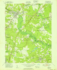
1951 Map of Laurel
USGS Topo · Published 1951About this map
The Patuxent River and Little Patuxent River define this mid-century landscape where Howard, Anne Arundel, and Prince Georges counties meet. The post-war expansion of the D.C.-Baltimore corridor is evident in the Washington-Baltimore Parkway (Under Construction) cutting through the wooded terrain. Major institutional footprints dominate the map, including the expansive Fort George G Meade Military Reservation and the Beltsville Research Center.
Find a feature on this map
52 named features on this map. Tap any name to fly to it.
Don’t see what you’re looking for? This feature index may not catch every label — zoom into the map to look around manually.
Map Details
Editions of this 1951 Laurel Map
This is the sole edition of this map. No revisions or reprints were ever made.
Other maps of this area

1892 · Laurel
USGS Topo · 1:62,500

1892 · Owensville
USGS Topo · 1:62,500

1894 · Laurel
USGS Topo · 1:62,500

1894 · Relay
USGS Topo · 1:62,500

1895 · Owensville
USGS Topo · 1:62,500

1897 · Laurel
USGS Topo · 1:62,500

1899 · Patuxent
USGS Topo · 1:125,000

1900 · Washington
USGS Topo · 1:62,500
1905 · Owensville
USGS Topo · 1:62,500
1906 · Patuxent
USGS Topo · 1:125,000