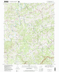
1996 Map of Laurel Springs
USGS Topo · Published 1999About this map
South Fork New River meanders through the high country of the Blue Ridge, marking the boundary between Ashe and Alleghany counties. This landscape is defined by its small farming communities and numerous country churches, such as Mt Zion Church, Bellview Ch, and Roan Creek Ch. The settlement of Laurel Springs serves as a local hub near the Parkway, while smaller hamlets like Furches and Scottville are tucked between the ridges. The terrain is notably steep, punctuated by peaks like The Peak, Ore Knob, and the prominent Peach Bottom Mountain. Several quarries and a network of older routes like Hoke Wagoner Road and Gentry Rd suggest the local history of resource extraction and transit before modern highway improvements changed the pace of life in these Appalachian highlands.
Find a feature on this map
52 named features on this map. Tap any name to fly to it.
Don’t see what you’re looking for? This feature index may not catch every label — zoom into the map to look around manually.
Map Details
Editions of this 1996 Laurel Springs Map
This is the sole edition of this map. No revisions or reprints were ever made.
Other maps of this area

1889 · Wytheville
USGS Topo · 1:125,000

1889 · Wilkesboro
USGS Topo · 1:125,000

1891 · Wilkesboro
USGS Topo · 1:125,000

1892 · Wytheville
USGS Topo · 1:125,000

1930 · Independence
USGS Topo · 1:48,000

1933 · Independence
USGS Topo · 1:62,500

1935 · Mouth of Wilson
USGS Topo · 1:48,000

1940 · Mouth of Wilson
USGS Topo · 1:62,500

1953 · Winston-Salem
USGS Topo · 1:250,000

1955 · Winston-Salem
USGS Topo · 1:250,000