
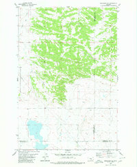
1979 Map of Lavina
USGS Topo · Published 1980About this map
The town of Lavina sits at a critical junction of rail and water in Golden Valley County. In this late-1970s landscape, the Chicago Milwaukee St Paul and Pacific railroad tracks parallel the winding path of the Musselshell River, illustrating the historical importance of the river corridor for transcontinental transport. The area is marked by a blend of agricultural infrastructure and distinct topographical features, including the Association Ditch irrigation system and the broad depression of Womans Pocket to the northwest.
Find a feature on this map
15 named features on this map. Tap any name to fly to it.
Don’t see what you’re looking for? This feature index may not catch every label — zoom into the map to look around manually.
Map Details
Editions of this 1979 Lavina Map
This is the sole edition of this map. No revisions or reprints were ever made.
Other maps of this area

1889 · Big Snowy Mountain
USGS Topo · 1:250,000

1893 · Big Snowy Mountain
USGS Topo · 1:250,000

1954 · Roundup
USGS Topo · 1:250,000

1958 · Roundup
USGS Topo · 1:250,000

1979 · Roundup
USGS Topo · 1:100,000

1979 · Bundy
USGS Topo · 1:24,000

1979 · Lavina NW
USGS Topo · 1:24,000

1979 · Timber Buttes South
USGS Topo · 1:24,000

1979 · Belmont
USGS Topo · 1:24,000
1980 · Broadview NE
USGS Topo · 1:24,000