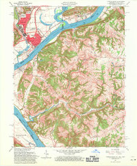
1961 Map of Lawrenceburg
USGS Topo · Published 1971About this map
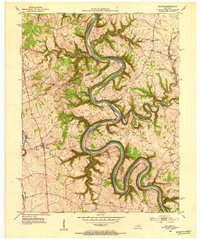
The Ohio River forms a complex tri-state boundary on this 1961 survey, where the Great Miami River and Whitewater River converge amidst a landscape of shifting industrial and agricultural use. The riverfront near Lawrenceburg and Petersburg shows the heavy infrastructure of the era, including the Baltimore and Ohio Railroad and the New York Central lines. Local commerce is anchored at Commissary Corner, while the interior of the quadrangle is defined by deep drainage systems like Woolper Creek and Tanners Creek. Genealogists will find a high density of family burial sites such as Tousey Cem, Dinsmore Cem, and Barnard Cem scattered across the uplands. This edition also captures the physical layout of the Fairgrounds and the prominent rising topography of Fort Hill and College Hill, which overlook the industrial Borrow Pit and gravel operations along the water.
Find a feature on this map
76 named features on this map. Tap any name to fly to it.
Don’t see what you’re looking for? This feature index may not catch every label — zoom into the map to look around manually.
Map Details
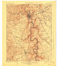
Editions of this 1961 Lawrenceburg Map
This is the sole edition of this map. No revisions or reprints were ever made.
Other maps of this area

1905 · Harrodsburg
USGS Topo · 1:125,000

1922 · Frankfort
USGS Topo · 1:48,000

1923 · Waddy
USGS Topo · 1:48,000
1924 · Frankfort
USGS Topo · 1:62,500

1925 · Mount Eden
USGS Topo · 1:48,000

1927 · Mount Eden
USGS Topo · 1:62,500
1951 · Lawrenceburg
USGS Topo · 1:24,000
1952 · Ashbrook
USGS Topo · 1:24,000
1952 · Salvisa
USGS Topo · 1:24,000
1952 · Mc Brayer
USGS Topo · 1:24,000