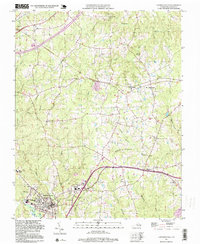
1997 Map of Lawrenceville
USGS Topo · Published 1999About this map
Lawrenceville serves as the focal point of this Southside Virginia landscape, characterized by a transition from organized town streets to the rolling drainage basins of Sturgeon Creek and Great Creek. The town's social history is visible through institutions like St Pauls Ch and the Lawrenceville Cem, while the outlying areas are defined by small rural hubs such as Dolphin and Edgerton.
Find a feature on this map
43 named features on this map. Tap any name to fly to it.
Don’t see what you’re looking for? This feature index may not catch every label — zoom into the map to look around manually.
Map Details
Editions of this 1997 Lawrenceville Map
This is the sole edition of this map. No revisions or reprints were ever made.
Other maps of this area

1918 · Lawrenceville
USGS Topo · 1:62,500

1919 · Mc Kenney
USGS Topo · 1:48,000

1919 · White Plains
USGS Topo · 1:48,000

1919 · Emporia
USGS Topo · 1:62,500

1920 · Lawrenceville
USGS Topo · 1:48,000

1920 · White Plains
USGS Topo · 1:62,500

1921 · Mc Kenney
USGS Topo · 1:62,500

1921 · Lawrenceville
USGS Topo · 1:62,500

1942 · Lawrenceville
USGS Topo · 1:62,500

1942 · Emporia
USGS Topo · 1:62,500