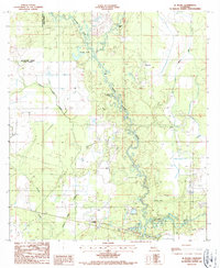
1986 Map of Le Blanc
USGS Topo · Published 1987About this map
The Whisky Chitto Creek meanders through the heart of this landscape, its winding course defining the timber and wetlands of western Allen Parish. The settlement of Le Blanc sits in the southern portion of the sheet near the Calcasieu River, while the smaller community of Harmony is located to the northeast. Transportation history is etched into the terrain by an Old Railroad Grade that cuts across the western woods, signaling the area's logging heritage. Local infrastructure is represented by Carpenters Bridge and a Landing Strip near the creek. The map also documents several oxbows and water bodies, including Crosby Lake, Red Bluff Lake, and Havard Lake, alongside a local Cem and a prominent Radio Tower, providing a detailed look at this rural Louisiana river corridor in the mid-1980s.
Find a feature on this map
18 named features on this map. Tap any name to fly to it.
Don’t see what you’re looking for? This feature index may not catch every label — zoom into the map to look around manually.
Map Details
Editions of this 1986 Le Blanc Map
This is the sole edition of this map. No revisions or reprints were ever made.
Other maps of this area

1935 · Mittie
USGS Topo · 1:31,680

1947 · Kinder
USGS Topo · 1:31,680

1947 · Oberlin
USGS Topo · 1:31,680

1947 · Pine Chapel
USGS Topo · 1:31,680

1947 · Le Blanc
USGS Topo · 1:31,680

1947 · Edna
USGS Topo · 1:31,680

1947 · Reeves
USGS Topo · 1:31,680

1947 · Thompson Bluff
USGS Topo · 1:31,680

1947 · Bundick
USGS Topo · 1:31,680
1948 · Mittie
USGS Topo · 1:24,000