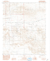
1984 Map of Leach Spring
USGS Topo · Published 1985About this map
Leach Spring serves as a vital water source in this mid-1980s topographic study of the high desert, situated between the Quail Mountains to the north and the Granite Mountains to the south. This area is dominated by the Fort Irwin Military Reservation, showcasing the infrastructure of a modern training installation. The landscape is marked by specialized features including a Landing Strip, a designated Target Area, and an engineered Levee. Transportation through this restricted zone is limited primarily to the Randsburg Road, which traverses the central corridor. The map provides a clear look at the intersection of natural desert topography and military utility, documenting the specific township and range boundaries that define this section of San Bernardino County.
Find a feature on this map
10 named features on this map. Tap any name to fly to it.
Don’t see what you’re looking for? This feature index may not catch every label — zoom into the map to look around manually.
Map Details
Editions of this 1984 Leach Spring Map
This is the sole edition of this map. No revisions or reprints were ever made.
Other maps of this area

1933 · Avawatz Mountains
USGS Topo · 1:250,000

1947 · Trona
USGS Topo · 1:250,000

1948 · Trona
USGS Topo · 1:250,000

1948 · Quail Mountains
USGS Topo · 1:62,500

1948 · Leach Lake
USGS Topo · 1:62,500

1948 · Goldstone Lake
USGS Topo · 1:62,500

1948 · Tiefort Mountains
USGS Topo · 1:62,500

1951 · Goldstone Lake
USGS Topo · 1:62,500

1951 · Tiefort Mountains
USGS Topo · 1:62,500

1951 · Quail Mountains
USGS Topo · 1:62,500