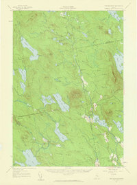
1957 Map of Lead Mtn
USGS Topo · Published 1959About this map
Lead Mtn rises above the glacial lake basins of Hancock and Washington counties in this late-1950s study. The terrain is defined by a dense network of remote water bodies, including Eagle Lake, Alligator Lake, and the sprawling Lower Sabao Lake. This region remains largely undeveloped, characterized by vast timberlands divided into townships like T 28 MD and T 34 MD. Small-scale human activity is marked by the crossroads at Dog Corners and a network of primitive transport routes such as the Springfield Jeep Trail and various Tote Roads used for forest access.
Find a feature on this map
127 named features on this map. Tap any name to fly to it.
Don’t see what you’re looking for? This feature index may not catch every label — zoom into the map to look around manually.
Map Details
Editions of this 1957 Lead Mtn Map
3 editions found

Other maps of this area

1902 · Cherryfield
USGS Topo · 1:62,500

1904 · Cherryfield
USGS Topo · 1:62,500

1911 · Ellsworth
USGS Topo · 1:62,500

1929 · Great Pond
USGS Topo · 1:48,000

1929 · Lead Mountain
USGS Topo · 1:48,000

1930 · Tunk Lake
USGS Topo · 1:48,000

1931 · Saponac
USGS Topo · 1:48,000

1932 · Tunk Lake
USGS Topo · 1:62,500

1932 · Nicatous Lake
USGS Topo · 1:48,000

1932 · Lead Mountain
USGS Topo · 1:62,500