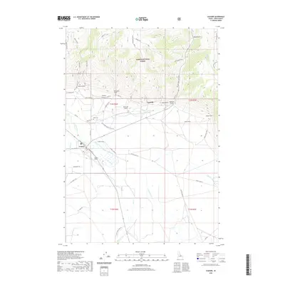
2020 Map of Leadore
USGS Topo · Published 2020About this map
Leadore stands at the base of the mountains where the Lemhi River meets Eighteenmile Creek. This high-altitude landscape is shaped by historical transit and ranching, evidenced by the convergence of the Old Hwy 28 and the remnants of the Railroad Canyon route. The map documents the overlap of public and private interests, with the boundaries of the Salmon National Forest defining the northern reaches, while legacy sites like the Old Leadore Ranger Station Rd and the Leadore Airport highlight the area's role as a regional hub. North of the primary settlement, Leadville and the Junction Cem provide critical touchpoints for genealogists and local historians tracing early high-mountain communities. The drainage patterns of Texas Creek and Canyon Cr emphasize the importance of water management in this high-desert environment, where access roads like Adams Ranch Rd connect remote operations to the central valley.
Find a feature on this map
60 named features on this map. Tap any name to fly to it.
Don’t see what you’re looking for? This feature index may not catch every label — zoom into the map to look around manually.
Map Details
Editions of this 2020 Leadore Map
This is the sole edition of this map. No revisions or reprints were ever made.
Other maps of this area

1955 · Dubois
USGS Topo · 1:250,000

1956 · Leadore
USGS Topo · 1:62,500

1956 · Morrison Lake
USGS Topo · 1:62,500

1958 · Dubois
USGS Topo · 1:250,000

1965 · Deadman Pass
USGS Topo · 1:24,000

1965 · Bannock Pass
USGS Topo · 1:24,000
1965 · Goat Mountain
USGS Topo · 1:24,000

1980 · Leadore
USGS Topo · 1:100,000
1987 · West of Leadore
USGS Topo · 1:24,000

1987 · Purcell Spring
USGS Topo · 1:24,000