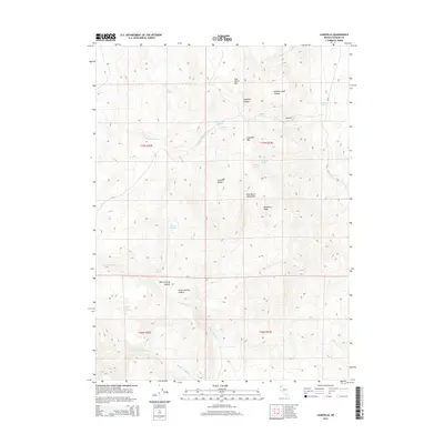
2015 Map of Leadville
USGS Topo · Published 2015About this map
Leadville sits at the high-elevation intersection of the Granite Range and the Hog Ranch Mountains, where the 2015 landscape is defined by its arid drainage networks and scattered water sources. The area's reliance on localized hydrology is evident in the numerous named watering points such as Leadville Springs, Chicken Spring, and Buckhorn Spring. These springs are often tucked into deep cuts like Leadville Canyon or Willow Creek Canyon, providing critical resources in a high-desert environment. The map shows the convergence of several major drainages, including N Fork Negro Cr and Grass Valley Cr, which cut through the complex topography of Buckhorn Peak and Hog Ranch Mtn. Only one primary route, CR 34, traverses the eastern edge of this territory, connecting the high peaks to the lower basins and emphasizing the isolation of the surrounding canyons and peaks.
Find a feature on this map
28 named features on this map. Tap any name to fly to it.
Don’t see what you’re looking for? This feature index may not catch every label — zoom into the map to look around manually.
Map Details
Editions of this 2015 Leadville Map
This is the sole edition of this map. No revisions or reprints were ever made.
Other maps of this area

1886 · Granite Range
USGS Topo · 1:250,000

1889 · Long Valley
USGS Topo · 1:250,000

1894 · Granite Range
USGS Topo · 1:250,000

1954 · Vya
USGS Topo · 1:250,000

1955 · Lovelock
USGS Topo · 1:250,000

1958 · Vya
USGS Topo · 1:250,000

1959 · Lovelock
USGS Topo · 1:250,000

1962 · Vya
USGS Topo · 1:250,000

1979 · Butte Spring
USGS Topo · 1:24,000
1979 · Chester Lyons Spring
USGS Topo · 1:24,000