
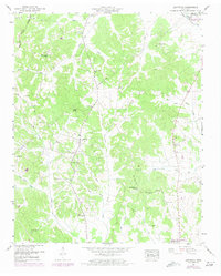
1949 Map of Leapwood
USGS Topo · Published 1952About this map
Leapwood stands at the center of this rural McNairy County landscape, situated where the ridge terrain begins to drop toward the bottomlands of Snake Creek. The area is defined by the Tennessee Divide in the northwest, a topographic boundary that separates the drainage systems of the Tennessee and Mississippi Rivers. Small community centers are anchored by local institutions like Mars Hill Ch and the Mud Creek Valley School, reflecting a mid-century social structure tied closely to the land.
Find a feature on this map
43 named features on this map. Tap any name to fly to it.
Don’t see what you’re looking for? This feature index may not catch every label — zoom into the map to look around manually.
Map Details
Editions of this 1949 Leapwood Map
2 editions found
Other maps of this area

1936 · Leapwood
USGS Topo · 1:24,000

1936 · Sardis
USGS Topo · 1:24,000

1936 · Milledgeville
USGS Topo · 1:24,000

1936 · Enville
USGS Topo · 1:24,000

1936 · Pittsburg Landing
USGS Topo · 1:24,000

1936 · Purdy
USGS Topo · 1:24,000

1936 · Stantonville
USGS Topo · 1:24,000

1936 · Mt. Peter
USGS Topo · 1:24,000

1949 · Pittsburg Landing
USGS Topo · 1:24,000

1949 · Mt. Peter
USGS Topo · 1:24,000