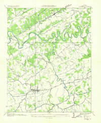
1934 Map of Lebanon
USGS Topo · Published 1934About this map
The winding course of the Clinch River dictates the landscape of this corner of Russell County, where mid-depression era farming and early industrial infrastructure intersect. The county seat of Lebanon appears as a developed center surrounded by smaller rural communities like Slabtown, Artrip, and the Coulwood P O settlement. This 1934 field examination reveals a reliance on local water power and resources, evidenced by Sikes Mill and Big Cedar Mill, as well as a Lime Kiln near Pullers. The topography is dominated by parallel ridges including Copper Ridge and Stone Ridge, which channel the various branches and creeks that feed the river system. A network of rural schools like Barretts Sch and Nash Ford Sch provides a glimpse into the localized social structure of the Virginia highlands before modern consolidation changed the rural character.
Find a feature on this map
65 named features on this map. Tap any name to fly to it.
Don’t see what you’re looking for? This feature index may not catch every label — zoom into the map to look around manually.
Map Details
Editions of this 1934 Lebanon Map
This is the sole edition of this map. No revisions or reprints were ever made.
Other maps of this area

1886 · Grundy
USGS Topo · 1:125,000

1890 · Grundy
USGS Topo · 1:125,000

1891 · Tazewell
USGS Topo · 1:125,000

1891 · Abingdon
USGS Topo · 1:125,000

1892 · Grundy
USGS Topo · 1:125,000

1894 · Abingdon
USGS Topo · 1:125,000

1895 · Tazewell
USGS Topo · 1:125,000

1897 · Tazewell
USGS Topo · 1:125,000

1897 · Bristol
USGS Topo · 1:125,000

1902 · Bristol
USGS Topo · 1:125,000