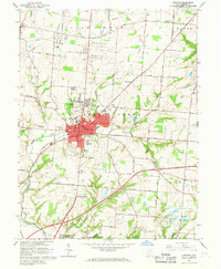
1966 Map of Lebanon
USGS Topo · Published 1968About this map
Lebanon serves as the focal point of this mid-1960s survey, showing a concentrated urban center characterized by an organized grid of institutional landmarks including the Courthouse, Armory, and Oakwood High Sch. The town's historical depth is evident in the multiple burial grounds found within and around its borders, such as the Pioneer Cem near the downtown area and the Old Stone Schoolhouse Cem to the northeast. Transportation patterns are defined by the Pennsylvania railroad line and a network of named country roads that connect the city to outlying settlements like Red Lion, Dodds, and Utica.
Find a feature on this map
71 named features on this map. Tap any name to fly to it.
Don’t see what you’re looking for? This feature index may not catch every label — zoom into the map to look around manually.
Map Details
Editions of this 1966 Lebanon Map
4 editions found
Other maps of this area

1904 · Mason
USGS Topo · 1:62,500

1906 · Mason
USGS Topo · 1:62,500

1908 · Miamisburg
USGS Topo · 1:62,500

1913 · Waynesville
USGS Topo · 1:62,500

1914 · Morrow
USGS Topo · 1:62,500

1915 · Waynesville
USGS Topo · 1:62,500

1916 · Morrow
USGS Topo · 1:62,500

1951 · Franklin
USGS Topo · 1:24,000

1953 · Cincinnati
USGS Topo · 1:250,000

1955 · Monroe
USGS Topo · 1:24,000