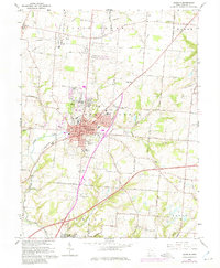
1966 Map of Lebanon
USGS Topo · Published 1975About this map
Lebanon serves as the focal point of this Warren County landscape, showing a mid-century town expanding its footprint through new residential subdivisions while maintaining its deep-rooted institutions. The map documents a dense concentration of civic and social infrastructure, ranging from the Fairgrounds and Armory to the Childrens Home and County Home. Educational history is well-represented by several district schools and specialized facilities like the Academy Sch and St Francis De Sales Sch.
Find a feature on this map
68 named features on this map. Tap any name to fly to it.
Don’t see what you’re looking for? This feature index may not catch every label — zoom into the map to look around manually.
Map Details
Editions of this 1966 Lebanon Map
4 editions found
Other maps of this area

1904 · Mason
USGS Topo · 1:62,500

1906 · Mason
USGS Topo · 1:62,500

1908 · Miamisburg
USGS Topo · 1:62,500

1913 · Waynesville
USGS Topo · 1:62,500

1914 · Morrow
USGS Topo · 1:62,500

1915 · Waynesville
USGS Topo · 1:62,500

1916 · Morrow
USGS Topo · 1:62,500

1951 · Franklin
USGS Topo · 1:24,000

1953 · Cincinnati
USGS Topo · 1:250,000

1955 · Monroe
USGS Topo · 1:24,000