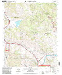
1995 Map of Lebec
USGS Topo · Published 2000About this map
The San Andreas Rift Zone carves a path through this high-altitude landscape where the Tehachapi Mountains meet the coastal ranges. At the heart of the map, Tejon Pass serves as the critical transit corridor, flanked by the high-desert communities of Lebec and Gorman. The topography is dominated by large historic land divisions such as the Castac Grant and La Liebre Grant, reflecting the region's ranching heritage. Water management is a defining modern feature, with the complex infrastructure of the California Aqueduct and its West Branch visible as they move water toward southern basins, feeding into Quail Lake. To the south, the Hungry Valley State Vehicular Recreation Area highlights the transition from early ranching lands to contemporary public recreation alongside the Los Padres National Forest.
Find a feature on this map
33 named features on this map. Tap any name to fly to it.
Don’t see what you’re looking for? This feature index may not catch every label — zoom into the map to look around manually.
Map Details
Editions of this 1995 Lebec Map
This is the sole edition of this map. No revisions or reprints were ever made.
Other maps of this area

1903 · Tejon
USGS Topo · 1:125,000

1933 · Quail
USGS Topo · 1:24,000

1933 · Gorman
USGS Topo · 1:24,000

1938 · Gorman
USGS Topo · 1:24,000

1938 · Quail
USGS Topo · 1:24,000

1942 · Tecuya Creek
USGS Topo · 1:24,000

1942 · Frazier Mountain
USGS Topo · 1:24,000

1943 · Neenach
USGS Topo · 1:62,500
1944 · Frazier Mountain
USGS Topo · 1:31,680
1945 · Pastoria Creek
USGS Topo · 1:31,680