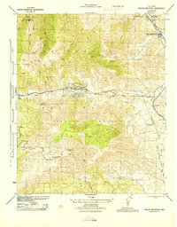
1944 Map of Frazier Mountain
USGS Topo · Published 1944About this map
Old Fort Tejon stands near the northeastern edge of this mid-century survey, anchoring a landscape where the high mountain passes of the Los Padres National Forest meet the early industrial infrastructure of Kern County. The terrain is marked by a legacy of resource extraction, from the Black Bob Mine in the north to the Frazier Mine situated high on the slopes of Frazier Mountain. This era captures the region's role in California's energy network, evidenced by the General Petroleum Corp Lebec Pumping Station and several transmission lines crossing near Tejon Pass.
Find a feature on this map
34 named features on this map. Tap any name to fly to it.
Don’t see what you’re looking for? This feature index may not catch every label — zoom into the map to look around manually.
Map Details
Editions of this 1944 Frazier Mountain Map
This is the sole edition of this map. No revisions or reprints were ever made.
Other maps of this area

1903 · Mt. Pinos
USGS Topo · 1:125,000

1903 · Tejon
USGS Topo · 1:125,000

1933 · Gorman
USGS Topo · 1:24,000

1938 · Gorman
USGS Topo · 1:24,000

1942 · Tecuya Creek
USGS Topo · 1:24,000

1942 · Frazier Mountain
USGS Topo · 1:24,000

1943 · Cuddy Valley
USGS Topo · 1:24,000

1943 · Lockwood Valley
USGS Topo · 1:24,000
1944 · Pleito Hills
USGS Topo · 1:31,680
1944 · Lockwood Valley
USGS Topo · 1:31,680