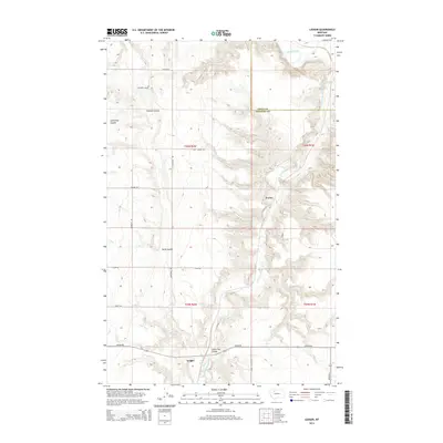
2014 Map of Ledger
USGS Topo · Published 2014About this map
The Marias River and its tributary, the Dry Fork Marias River, carve deep, winding incisions through this High Plains landscape on the border of Pondera and Toole Counties. This agricultural environment is defined by an intricate network of irrigation infrastructure, including the S Canal, E Ditch, and F Four Ditch, which support the farms surrounding the small settlements of Ledger and Fowler. The terrain is marked by significant coulees such as Pearson Coulee and Swift Coulee, while local history is etched into the land via the Fort Conrad Trl. A grid of rural roads like Liberty School Rd and Depot Rd connects these isolated homesteads, reflecting a century-old pattern of Montana dryland farming and river-basin ranching.
Find a feature on this map
26 named features on this map. Tap any name to fly to it.
Don’t see what you’re looking for? This feature index may not catch every label — zoom into the map to look around manually.
Map Details
Editions of this 2014 Ledger Map
This is the sole edition of this map. No revisions or reprints were ever made.
Other maps of this area

1920 · Conrad
USGS Topo · 1:125,000

1954 · Shelby
USGS Topo · 1:250,000

1958 · Shelby
USGS Topo · 1:250,000
1967 · Conrad
USGS Topo · 1:24,000

1967 · Naismith
USGS Topo · 1:24,000

1967 · Conrad Butte
USGS Topo · 1:24,000

1967 · Dunkirk
USGS Topo · 1:24,000
1967 · Pioneer School
USGS Topo · 1:24,000

1967 · Fowler Coulee NW
USGS Topo · 1:24,000
1967 · Letz Lake
USGS Topo · 1:24,000