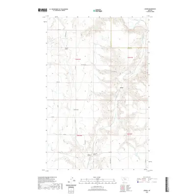
2020 Map of Ledger
USGS Topo · Published 2020About this map
Ledger and the neighboring siding of Fowler sit within a landscape of carved coulees and managed waterways near the Toole and Pondera County line. The area is defined by the winding course of the Marias River and its tributary, the Dry Fork Marias River, which cut deep paths through the high plains. A complex network of irrigation infrastructure is evident, including the S Canal, E Ditch, and F Four Ditch, indicating the region's reliance on water management for agriculture. Local history and ranching roots are preserved in the naming of features such as Pearson Coulee, Swift Coulee, and Little Flat Coulee. For those tracing historical transit, the presence of the Fort Conrad Trl and roads like Liberty School Rd and Depot Rd point toward the essential corridors that connected these rural Montana communities to the wider region.
Find a feature on this map
29 named features on this map. Tap any name to fly to it.
Don’t see what you’re looking for? This feature index may not catch every label — zoom into the map to look around manually.
Map Details
Editions of this 2020 Ledger Map
This is the sole edition of this map. No revisions or reprints were ever made.
Other maps of this area

1920 · Conrad
USGS Topo · 1:125,000

1954 · Shelby
USGS Topo · 1:250,000

1958 · Shelby
USGS Topo · 1:250,000
1967 · Conrad
USGS Topo · 1:24,000

1967 · Naismith
USGS Topo · 1:24,000

1967 · Conrad Butte
USGS Topo · 1:24,000

1967 · Dunkirk
USGS Topo · 1:24,000
1967 · Pioneer School
USGS Topo · 1:24,000

1967 · Fowler Coulee NW
USGS Topo · 1:24,000
1967 · Letz Lake
USGS Topo · 1:24,000