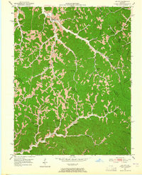
1951 Map of Lee City
USGS Topo · Published 1965About this map
Lee City serves as a central point in this early 1950s survey, where the Red River carves through a landscape defined by an intricate network of narrow hollows and ridge-top settlements. The map reveals a dense distribution of rural infrastructure, particularly the high concentration of neighborhood schools like the Negro Branch Sch and Upper Gilmore Sch, reflecting the community-centric geography of Wolfe County before mid-century consolidation. Educational and religious life are deeply rooted here, evidenced by the Magoffin Institute and numerous family burying grounds such as Taulbee Cem and Halsey Cem. Transport follows the water, with roads tracing the winding paths of Frozen Creek and Johnson Creek. An isolated Gas Well near the Field Branch Cem hints at the burgeoning resource extraction beginning to touch these traditional farming and timbering corridors.
Find a feature on this map
66 named features on this map. Tap any name to fly to it.
Don’t see what you’re looking for? This feature index may not catch every label — zoom into the map to look around manually.
Map Details
Editions of this 1951 Lee City Map
This is the sole edition of this map. No revisions or reprints were ever made.
Other maps of this area

1889 · Salyersville
USGS Topo · 1:125,000

1891 · Salyersville
USGS Topo · 1:125,000

1899 · Salyersville
USGS Topo · 1:125,000

1951 · Cannel City
USGS Topo · 1:24,000

1951 · Guage
USGS Topo · 1:24,000

1951 · Landsaw
USGS Topo · 1:24,000

1951 · White Oak
USGS Topo · 1:24,000

1951 · Hazel Green
USGS Topo · 1:24,000

1951 · Seitz
USGS Topo · 1:24,000

1951 · Quicksand
USGS Topo · 1:24,000