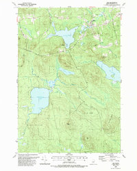
1988 Map of Lee
USGS Topo · Published 1988About this map
The town of Lee serves as the primary hub in this late-1980s landscape, characterized by an expansive network of interconnected water bodies and prominent ridges. Notable for its educational and civic sites, the area includes the Mt Jefferson Jr High Sch and several historic burial grounds, such as Woodlawn Cem and the Mt Jefferson Jr High Sch Academy Cem. The hydrology of the region is dominated by Silver Lake, which features a boat ramp and Coles Landing on its southern shore, alongside the large expanse of Madagascar Pond to the southwest. Rising above the lowlands are several named peaks including Mt Jefferson, Lookout Mtn, and Porcupine Mtn. The map also captures the local industrial footprint through several Gravel Pits and the timber-focused geography of t3 r1 Nbpp and Burlington township lines.
Find a feature on this map
53 named features on this map. Tap any name to fly to it.
Don’t see what you’re looking for? This feature index may not catch every label — zoom into the map to look around manually.
Map Details
Editions of this 1988 Lee Map
This is the sole edition of this map. No revisions or reprints were ever made.
Other maps of this area

1920 · Winn
USGS Topo · 1:62,500

1931 · Springfield
USGS Topo · 1:48,000

1931 · Saponac
USGS Topo · 1:48,000

1932 · Nicatous Lake
USGS Topo · 1:48,000

1934 · Saponac
USGS Topo · 1:62,500

1934 · Nicatous Lake
USGS Topo · 1:62,500

1934 · Springfield
USGS Topo · 1:62,500

1954 · Millinocket
USGS Topo · 1:250,000

1957 · Saponac
USGS Topo · 1:62,500

1958 · Millinocket
USGS Topo · 1:250,000