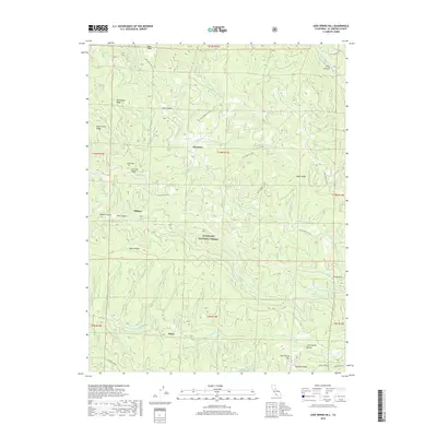
2018 Map of Leek Spring Hill
USGS Topo · Published 2018About this map
Eldorado National Forest defines this high-elevation landscape, where the headwaters of major drainage systems diverge across the Sierra Nevada. The terrain is structured by a series of prominent ridges, including Alder Ridge, Mill Creek Ridge, and Plummer Ridge, which separate the deep incisions of Dennis Canyon and Light Canyon. Small settlements like Meiss, Morrison, and Pilliken are situated among the network of forest service roads, such as 11N46 Forest Svc Rd.
Find a feature on this map
50 named features on this map. Tap any name to fly to it.
Don’t see what you’re looking for? This feature index may not catch every label — zoom into the map to look around manually.
Map Details
Editions of this 2018 Leek Spring Hill Map
This is the sole edition of this map. No revisions or reprints were ever made.
Other maps of this area

1889 · Pyramid Peak
USGS Topo · 1:125,000

1891 · Pyramid Peak
USGS Topo · 1:125,000

1895 · Pyramid Peak
USGS Topo · 1:125,000

1896 · Pyramid Peak
USGS Topo · 1:125,000

1947 · Sacramento
USGS Topo · 1:250,000

1948 · Sacramento
USGS Topo · 1:250,000

1950 · Riverton
USGS Topo · 1:24,000
1951 · Stump Spring
USGS Topo · 1:24,000

1951 · Leek Spring Hill
USGS Topo · 1:24,000
1951 · Caldor
USGS Topo · 1:24,000