
1951 Map of Leek Spring Hill
USGS Topo · Published 1971About this map
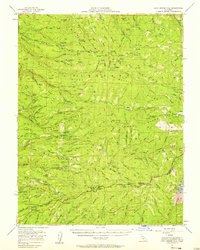
Eldorado National Forest dominates this 1951 study of the high timber country along the boundary of El Dorado and Amador Counties. The landscape is defined by the steep canyons of the North Fork, Middle Fork, and South Fork Cosumnes River, where narrow ridges like Baltic Ridge and Plummer Ridge separate the watercourses. This era shows an active industrial landscape before the full shift to modern recreation; the map identifies numerous historical resource extraction points such as the Arbor Mine, Spread Eagle Mine, and the sites of the Girard Mill and Tuman Mill.
Find a feature on this map
144 named features on this map. Tap any name to fly to it.
Don’t see what you’re looking for? This feature index may not catch every label — zoom into the map to look around manually.
Map Details
Editions of this 1951 Leek Spring Hill Map
3 editions found

Other maps of this area

1889 · Jackson
USGS Topo · 1:125,000

1889 · Pyramid Peak
USGS Topo · 1:125,000

1891 · Big Trees
USGS Topo · 1:125,000

1891 · Placerville
USGS Topo · 1:125,000

1891 · Pyramid Peak
USGS Topo · 1:125,000

1892 · Jackson
USGS Topo · 1:125,000

1892 · Placerville
USGS Topo · 1:125,000

1893 · Placerville
USGS Topo · 1:125,000

1894 · Big Trees
USGS Topo · 1:125,000

1895 · Pyramid Peak
USGS Topo · 1:125,000