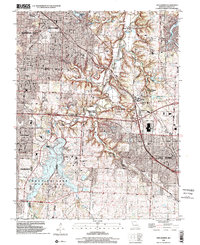
1996 Map of Lees Summit
USGS Topo · Published 2002About this map
The Little Blue River valley serves as a primary geographical axis for this mid-1990s survey, showing the expanding suburban footprints of Lees Summit and Grandview against the established neighborhoods of Kansas City and Raytown. The landscape is defined by large-scale public and institutional works, most notably the Longview Lake and its surrounding Longview Lake County Park, which dominates the southwestern quadrant. Cultural and educational history is represented by the Unity Village campus, home to the School of Christianity, while the K C Metropolitan Jr College indicates the era's regional educational infrastructure. Transportation corridors such as the Kansas City Southern railway and Blue Ridge Blvd connect older settlements like Knobtown and Vale to the modern metropolitan grid. Several prominent cemeteries, including Mt Olivet Cemetery and the Gantrell Cem, provide essential points of reference for genealogical researchers studying the Jackson County area.
Find a feature on this map
40 named features on this map. Tap any name to fly to it.
Don’t see what you’re looking for? This feature index may not catch every label — zoom into the map to look around manually.
Map Details
Editions of this 1996 Lees Summit Map
This is the sole edition of this map. No revisions or reprints were ever made.
Other maps of this area

1887 · Harrisonville
USGS Topo · 1:125,000

1887 · Olathe
USGS Topo · 1:125,000

1890 · Kansas City
USGS Topo · 1:125,000

1892 · Harrisonville
USGS Topo · 1:125,000

1893 · Olathe
USGS Topo · 1:125,000

1894 · Kansas City
USGS Topo · 1:125,000

1894 · Harrisonville
USGS Topo · 1:125,000

1894 · Independence
USGS Topo · 1:125,000

1933 · Blue Springs
USGS Topo · 1:24,000

1934 · Independence
USGS Topo · 1:24,000