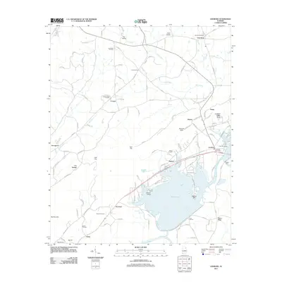
2011 Map of Leesburg
USGS Topo · Published 2011About this map
Weiss Lake dominates this Alabama landscape, with its irregular shoreline creating a complex network of points and coves. The presence of the Weiss Dam and the Weiss Lake Dike highlights the mid-century engineering that transformed the Coosa River valley. The town of Leesburg sits at the eastern edge of the water, serving as a hub for the surrounding rural communities. Settlement patterns are concentrated along the highway corridors, particularly near Mackey and Bristow. Significant elevation changes are marked by features like Big Mountain and Rock City, while the local history is preserved in numerous burial grounds such as Cedar Hill Cemetery and Mount Lookout Cemetery. Smaller outlying settlements like Sand Rock and Slackland are connected by a web of county roads, reflecting a landscape defined by both modern recreation at Pine Cove Marina and traditional agricultural roots.
Find a feature on this map
131 named features on this map. Tap any name to fly to it.
Don’t see what you’re looking for? This feature index may not catch every label — zoom into the map to look around manually.
Map Details
Editions of this 2011 Leesburg Map
This is the sole edition of this map. No revisions or reprints were ever made.
Other maps of this area

1893 · Fort Payne
USGS Topo · 1:125,000

1898 · Fort Payne
USGS Topo · 1:125,000

1900 · Fort Payne
USGS Topo · 1:125,000

1936 · Crossville
USGS Topo · 1:24,000

1936 · Roden Gap
USGS Topo · 1:24,000

1946 · Portersville
USGS Topo · 1:24,000
1947 · Portersville
USGS Topo · 1:24,000
1949 · Crossville
USGS Topo · 1:24,000

1955 · Rome
USGS Topo · 1:250,000

1958 · Rome
USGS Topo · 1:250,000