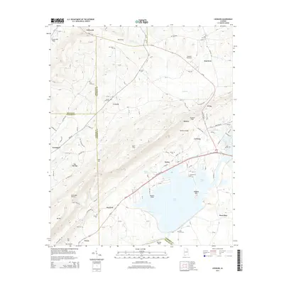
2014 Map of Leesburg
USGS Topo · Published 2014About this map
Weiss Lake and its intricate shoreline dominate the southern landscape of this Northeast Alabama quadrangle, where the Coosa River bends around Ballplay Bend. The terrain is defined by the sharp rise of Lookout Mountain and Shinbone Ridge, creating a series of valleys such as Little Wills Valley and Shinbone Valley. This landform-rich area contains a network of small, established settlements including Leesburg, Collinsville, and Sand Rock. Numerous family and community burial sites are documented throughout the hills, including New Bethel Cem, Pine Grove Cem, and Mackey Cem. The map illustrates the convergence of high-ground landmarks like Rock City with the low-lying wetlands of Tillery Cove, reflecting the complex geography of the Cherokee and Etowah county lines.
Find a feature on this map
63 named features on this map. Tap any name to fly to it.
Don’t see what you’re looking for? This feature index may not catch every label — zoom into the map to look around manually.
Map Details
Editions of this 2014 Leesburg Map
This is the sole edition of this map. No revisions or reprints were ever made.
Other maps of this area

1893 · Fort Payne
USGS Topo · 1:125,000

1898 · Fort Payne
USGS Topo · 1:125,000

1900 · Fort Payne
USGS Topo · 1:125,000

1936 · Crossville
USGS Topo · 1:24,000

1936 · Roden Gap
USGS Topo · 1:24,000

1946 · Portersville
USGS Topo · 1:24,000
1947 · Portersville
USGS Topo · 1:24,000
1949 · Crossville
USGS Topo · 1:24,000

1955 · Rome
USGS Topo · 1:250,000

1958 · Rome
USGS Topo · 1:250,000