
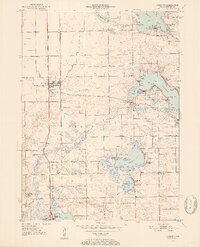
1950 Map of Leesburg
USGS Topo · Published 1952About this map
The Tippecanoe River snakes through a landscape defined by glacial lakes and specialized transport networks in this mid-century Indiana survey. The town of Leesburg and the settlement at Oswego anchor a region where recreation and local industry meet, shown through the cluster of parks such as Potawatomi Park and Wa-Will-Away Park. This era highlights a transition in regional travel, as the New York Central Railroad and the Winona Railroad parallel one another north-to-south, while the Warsaw Municipal Airport appears as a significant modern landmark on the outskirts of the county seat's reach. For genealogists and local historians, the map preserves specific church and community sites like New Salem Ch and the cluster of landings along Big Chapman Lake, including Osborn Landing and Stoneberger Landing, reflecting the area's development as a permanent residential and seasonal destination.
Find a feature on this map
55 named features on this map. Tap any name to fly to it.
Don’t see what you’re looking for? This feature index may not catch every label — zoom into the map to look around manually.
Map Details
Editions of this 1950 Leesburg Map
2 editions found
Other maps of this area

1950 · Pierceton
USGS Topo · 1:24,000

1950 · North Webster
USGS Topo · 1:24,000

1951 · Milford
USGS Topo · 1:24,000

1951 · Wawasee
USGS Topo · 1:24,000

1953 · Fort Wayne
USGS Topo · 1:250,000

1956 · Fort Wayne
USGS Topo · 1:250,000

1957 · Warsaw
USGS Topo · 1:24,000

1958 · Nappanee East
USGS Topo · 1:24,000

1959 · Atwood
USGS Topo · 1:24,000
1961 · Lake Wawasee
USGS Topo · 1:24,000