
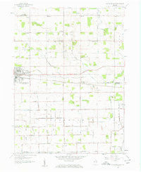
1958 Map of Nappanee East
USGS Topo · Published 1960About this map
The northern reaches of Kosciusko County and southern Elkhart County are defined by a meticulous grid of rural roads and drainage ditches in this 1958 topographic study. The city of Nappanee anchors the western edge, where the Baltimore and Ohio railroad line cuts a straight path eastward toward the small settlement of Gravelton. This landscape is primarily agricultural, evidenced by the dense network of named agricultural drainage systems such as the Omar-Neff ditch and the Fisher-Gordon ditch, which were essential for reclaiming the wet prairie land for farming.
Find a feature on this map
50 named features on this map. Tap any name to fly to it.
Don’t see what you’re looking for? This feature index may not catch every label — zoom into the map to look around manually.
Map Details
Editions of this 1958 Nappanee East Map
2 editions found
Other maps of this area

1950 · Leesburg
USGS Topo · 1:24,000

1951 · Milford
USGS Topo · 1:24,000

1953 · Fort Wayne
USGS Topo · 1:250,000

1953 · Chicago
USGS Topo · 1:250,000

1956 · Fort Wayne
USGS Topo · 1:250,000

1957 · Chicago
USGS Topo · 1:250,000

1958 · Nappanee West
USGS Topo · 1:24,000

1958 · Bourbon
USGS Topo · 1:24,000

1959 · Atwood
USGS Topo · 1:24,000

1959 · Goshen
USGS Topo · 1:24,000