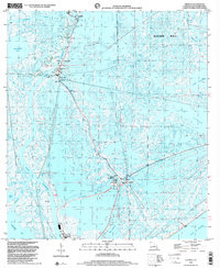
1998 Map of Leeville
USGS Topo · Published 2001About this map
Bayou Lafourche cuts through the center of this coastal landscape, serving as the primary corridor for the communities of Leeville and Pointe Fourchon. By the late 1990s, the region's geography is defined by a dense network of industrial infrastructure supporting the Leeville Gas and Oil Field, including numerous radio towers, water tanks, and a heliport. This area represents a critical intersection of Louisiana's petroleum industry and its fragile coastal marshes, where human engineering is visible in the straight lines of the Southwestern Louisiana Canal and Havoline Canal that slice through the wetlands.
Find a feature on this map
29 named features on this map. Tap any name to fly to it.
Don’t see what you’re looking for? This feature index may not catch every label — zoom into the map to look around manually.
Map Details
Editions of this 1998 Leeville Map
This is the sole edition of this map. No revisions or reprints were ever made.
Other maps of this area

1892 · Cheniere Caminada
USGS Topo · 1:62,500

1892 · Creole
USGS Topo · 1:62,500

1894 · Timbalier
USGS Topo · 1:62,500

1894 · Lake Felicity
USGS Topo · 1:62,500

1935 · Bay Courant
USGS Topo · 1:31,680

1935 · Pelican Pass
USGS Topo · 1:31,680

1935 · Mink Bayou
USGS Topo · 1:31,680

1935 · Calumet Island
USGS Topo · 1:31,680

1935 · Leeville
USGS Topo · 1:31,680

1939 · Lake Felicity
USGS Topo · 1:62,500